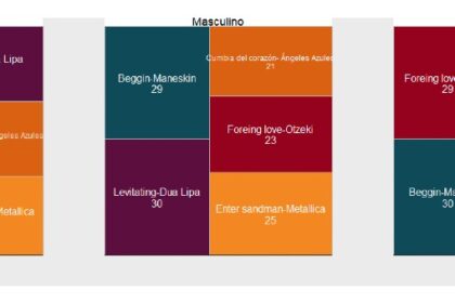
Este es el tercer artículo de la serie sobre cómo usar ggplo2 en R para diseñar mejores gráficos periodísticos. En esta ocasión te mostraré cómo crear un mapa de árbol o tree map.


Este es el tercer artículo de la serie sobre cómo usar ggplo2 en R para diseñar mejores gráficos periodísticos. En esta ocasión te mostraré cómo crear un mapa de árbol o tree map.

The history of mankind is linked to that of fire, but when people deliberately or negligently cause fires, they have devastating consequences for the environment, health and safety of others. In the last decade, Mexico has had more than 85,000 forest fires that have devoured 4.6 million hectares of territory. Natural causes represent less than 10% of the total area destroyed, meaning that only 1 in 100 conflagrations were caused by nature itself.

Hasta 2017, por cada 1.000 mexicanos había, aproximadamente, 364 vehículos debidamente registrados. Si retrocediéramos a 1980 esa cifra se reduce significativamente. Era apenas de 83 por cada 1.000 habitantes.
En menos de cuatro décadas el parque vehicular del país incrementó más de cuatro veces